GPSKinect
GPSKinect Overview
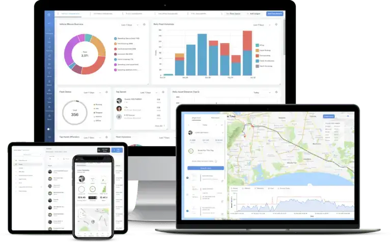
GPSKinect is IoTKinect’s cornerstone solution for real-time tracking, monitoring, and analytics of moving or remote resources. Built on a scalable, cloud-ready infrastructure, GPSKinect marries precise geolocation data with advanced sensor insights to deliver a complete picture of your operations—whether you oversee a small local fleet or a sprawling, cross-regional network of assets.
What Sets GPSKinect Apart?
1. Real-Time Visibility:
Immediate, map-based visualization of every tracked unit (vehicle, vessel, or otherwise). In-dashboard alerts for route deviations, unauthorized usage, or sensor anomalies.
2. Intelligent Geofencing:
Define custom virtual boundaries around job sites, high-traffic areas, or secure compounds. Automatic notifications for enter/exit events help deter theft, limit zone overlap, and optimize scheduling.
3. Robust Sensor Integration:
Plug in temperature, humidity, cargo load, or other specialized sensors for 360° operational insights. Streamlined data collection via standard protocols (BLE, GPS trackers, and more).
4. Actionable Analytics & Reporting:
Comprehensive dashboards that combine real-time feeds with historical trend data. Generate granular reports on vehicle utilization, driver performance, route efficiency, and more.
5. Flexible Architecture:
Easily integrates with third-party systems or other IoTKinect modules (e.g., EdgeKinect, KinectLNS, SimsKinect). Supports both modern RESTful APIs and secure data channels for enterprise-level deployments.
How GPSKinect Fits Into Your Ecosystem
Companies of all sizes and across various industries use GPSKinect to:
- Reduce Operational Costs: Identify inefficient routes, minimize unauthorized usage, and optimize dispatch.
- Enhance Security: Prevent theft or misuse of fleet vehicles and high-value assets.
- Improve Customer Satisfaction: Provide transparent delivery timelines, more precise ETAs, and faster response to service calls.
- Support Data-Driven Decisions: Uncover trends in how assets are used, then refine workflows to reduce downtime or avoid bottlenecks.
GPSKinect’s Sub-Modules
While GPSKinect provides a universal platform for location intelligence, it also includes four specialized sub-modules. Each sub-module tailors the core GPSKinect functionality to a specific operational context:
1. Assets
Focus: Static or portable assets (equipment, containers, cargo) that need close tracking.
Ideal For:High-value, sensitive, or frequently relocated items.
2. Vehicles
Focus: Road-based fleets—delivery vans, buses, service trucks, etc.
Features: In-depth fleet management (driver behavior, fuel usage, maintenance scheduling).
3. Ferries
Focus: Maritime operations—short sea routes, passenger ferries, smaller cargo vessels.
Advantage: Marine-specific sensors and dual connectivity for open-water conditions.
4. First Responders
Focus: The emergency responder's position is being tracked via GPS to ensure a quick response time for the ambulance/police/fire truck.
Critical Benefit: Real-time data, rapid dispatch, mission-critical alerts to improve response times.
Additional Benefits & Differentiators
1. Scalability & Reliability
Deployed on robust cloud infrastructure with built-in redundancies. Elastic resource allocation means GPSKinect grows with your fleet and operational complexity.
2. User-Friendly Interface
Intuitive dashboards for users at all levels, from operations managers to ground-level technicians. Drag-and-drop tools for geofence creation and sensor onboarding reduce the learning curve.
3. Security & Compliance
End-to-end data encryption for device-to-cloud communications. Role-based access control restricts sensitive information to authorized personnel.
4. Modular Integration
Seamlessly connects with other IoTKinect platforms, such as EdgeKinect for edge processing or KinectLNS for LoRaWAN network orchestration. Comprehensive APIs allow for third-party application integration or custom interface development.
5. Rich Alerting Mechanisms
Multi-channel alerts (email, SMS, push notifications) keep key stakeholders informed, even on the move. Configurable thresholds for speed, temperature, idle time, or zone boundaries.
GPSKinect is more than just a GPS tracking tool. It’s a holistic location intelligence platform that harmonizes real-time positioning, advanced sensor data, and actionable analytics—delivering unparalleled visibility into how your assets and vehicles move and operate.
By housing specialized sub-modules—Assets, Vehicles, Ferries, and First Responders—GPSKinect addresses diverse operational requirements under one unified system. This ensures consistent data, reduced integration overhead, and a clear path to improving efficiency and safety across your organization.
Whether you’re running a fleet of delivery trucks, operating a ferry line, or coordinating emergency responses, GPSKinect offers real-time tracking, intuitive control, and data-driven insights to help you make smarter decisions and deliver better outcomes.